Design Automation Lab
The Möbius Ecosystem
A web-based ecosystem for parametric modelling.
Möbius Spatial Information Model (SIM)
Möbius Spatial Information Model (SIM) in a Javascript/Typescript library for generating and manipulating 3D spatial information.
SIM Conceptual Model
The SIM Conceptual Model defines how spatial information is representated.
The conceptual model strives to be a highly generic type of representation that can be used to represent a wide variety of types of spatial information. It has no concepts that are specific to any type of products, such as buildings, cities, and so forth. Such concepts can be added to the representation by the user, through user-defined collections, semantics, and connectivity.
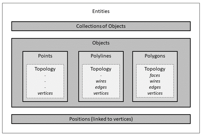
Entities
The conceptual model defines a set of entities and attributes.
Entities represent the geometry and topology of the spatial information. Attributes represent the semantics of the spatial information. Attributes are key-value pairs that can be attached to any type of entity.
Various different types of entities are defined.
- Model: At the top level, there is the model entity that encapsulates the whole model.
- Collections: A model can contain zero or more collections. A collection is an aggregation that can contain either objects or other collections.
- Objects: A model can contain zero geometric entities called objects. Three types of objects are defined: polygons, polylines, and points.
- Topology: Objects have an internal topological structure made up of topological entities. There are three types of topological entities: wires, edges, and vertices.
- Positions: A model can contain positions. Positions represent specific locations in the
model, specified by an
xyzattribute, whose value is a list of three numbers. This attribute is non-optional. It is the only required attribute in the SIM conceptual model.
Overall, there are therefore 9 types of entities:
- models
- collections
- polygons, polylines, points
- wires, edges, vertices
- positions
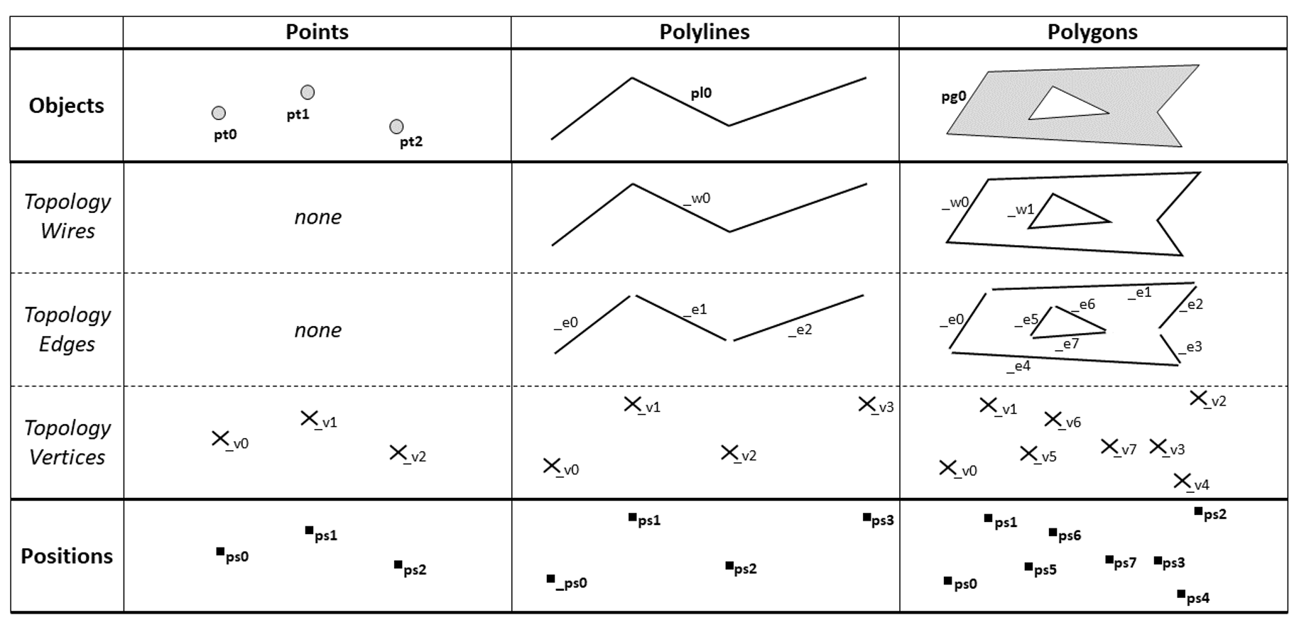
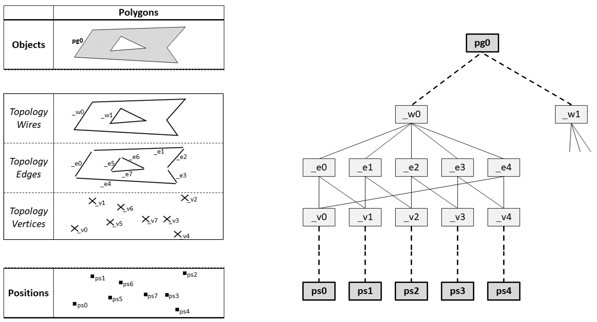
Topology
A wire consists of a sequence of edges and a sequence of vertices. Each edge connects exactly two vertices. If a wire is closed, then the number of edges is equal to the number of vertices. If a wire is open, then the number of edges is one less than the number of vertices.
Every vertex is linked to exactly one position. The xyz attribute of the position defines the
location of the vertex.
Each type of object has a specific topological structure.
- Polygons are defined by a list of closed wires. The first wire defines the outer boundary of the polygon. Subsequent wires define holes within the polygon.
- Polylines are defined by a single wire that can be either open or closed.
- Points are defined by a single vertex.
Topological entities are created and destroyed based on specific modelling operations. The user cannot directly create topological entities. For example, when a user creates a polyline, the wire, edges, and vertices will be automatically created.
Attributes
Attributes can be added to any type of entity. An attribute has a unique name and a value. The name is a string. The value can have the following types:
- number (float or integer)
- string
- boolean
- list, e.g.
[1,2,3] - dictionary, e.g.
{"a":1, "b":2, "c":3}
The list or dictionary data structures can contain numbers, strings, booleans or other lists or dictionaries.
User-defined Collections
Users can organise their spatial information in complex ways using collections. Collections can contain heterogeneous sets of objects, and can be nested to create hierarchies. This allows representations to be defined that decompose models into different parts. In addition, objects can be members of multiple collections, thereby allowing multiple representational schemas to be applied at the same time.
For example, a user creating a model of an urban neighbourhood may create collections for each building and a collection for the roof polygons of all buildings (perhaps for solar PV potential analysis). Each roof polygon would then be in two collections, the building and the ‘roofs’.
User-defined Semantics
Users can define custom semantics by adding attributes to any of the entities in the model. This allows users to customise the data representation to their particular use case. In existing spatial representations such as GeoJSON, attributes can only be added to objects. The ability to add attributes to the model, to collections, and to topological entities (wires, edges, and vertices) is a powerful feature.
For example, a user creating a model of a number of buildings can create a collection for each building and then add attributes that describe properties of the building, for instance the total floor area.
User-defined Connectivity
Users can create custom connectivity relationships between objects in the model. By sharing positions, vertices in objects can become welded. In other spatial data representations, creating such connections is either not possible, or specific types of relationships are hard-coded into the representation. With the SIM approach, users can define their own connectivity relationships based on their use cases.
For example, for certain types of network analysis, a user may want to create connectivity relationships between polylines representing street networks.
Möbius Programming
See Möbius Programming for more information.